Correlation between Different Factors of Non-point Source Pollution in Yangtze River Basin
Climate Change Biology HydrologyEnvironmental SciencesSoil ScienceReceived 08 Oct 2024 Accepted 22 Oct 2024 Published online 23 Oct 2024
ISSN: 2995-8067 | Quick Google Scholar
Previous Full Text
Support for the use of Binomial Nomenclature in the Taxonomy of Viruses

Received 08 Oct 2024 Accepted 22 Oct 2024 Published online 23 Oct 2024
This research used the improved export coefficient model to estimate non-point source load in sub-watersheds and a self-organizing map model to identify the correlation relationship of factors, that can be affected by non-point source load in Yangtze River Basin. Research results indicate that total nitrogen load is 4.87 - 15.53 kg/ha; total phosphorus load is 0.18 - 0.51 kg/ha; Dong Ting Lake sub-basin has the lowest contribution value of total nitrogen and phosphorus; Tai Lake sub-basin has the highest contribution load of total nitrogen and total phosphorus; Jinsha River sub-basin reveals the highest value of total nitrogen and phosphorus contribution on grassy land and desert land; Tai Lake sub-basin has the highest total nitrogen and total phosphorus load on forest, agricultural land, and urban construction land. The correlation relationship of factors reveals a very close correlation with each other as precipitation, total nitrogen load, and total phosphorus load factors have correlation in the highest value, in which total nitrogen load and total phosphorus load factors have a close correlation with each other from the lowest value to highest value; wetland and barren land factors correlate with the lowest value and the highest value; agricultural land, forestland, and grassy land factors correlate with one another in the high value and the highest value. The forest cover rate factor, as well as the population factor, does not correlate with other factors.
In the world, non-point source (NPS) has become one of the important factors affecting the water environment and water ecological security in the basin [1]. Non-point source (NPS) pollution refers to diffuse contamination, which is not discharged from a few localized points or single indefinable sources [2]. Unlike pollution from industrial and sewage treatment plants, non-point source (NPS) pollution comes from many diffuse sources [3] and the rapid development of urbanization and agriculture has accelerated nonpoint source (NPS) pollution that has led to the deterioration of surface water quality [4]. The nutrient input pathways include irrigation, fertilization, seeding, atmospheric deposition, and biological nitrogen fixation, while the output pathways consist of plant uptake, surface runoff, leaching, and other direct discharges of agricultural/rural wastes into the environment [5], in which NPS pollution from agricultural runoff is among the major causes of pollution found in water bodies [6]. NPS inputs, especially from agricultural activity, have resulted in large amounts of nitrogen (N) and phosphorous (P) [7,8]. As the runoff moves, it picks up and carries natural and anthropogenic pollutants, finally depositing them into lakes, rivers, wetlands, coastal waters, and groundwater systems [3]. A small portion of chemicals is absorbed by crops, and the rest remains in the soil [9].
Non-point source pollution has become the main source of water environmental pollution in recent years [10] and its results are developed via several computer simulation models and model techniques [11] because they provide a quantitative description for the entire basin system, and aid in the analysis of spatial and temporal features of NPS pollution [3]. They also provide estimates of the different effects of various land use, management, and technical measures on NPS pollution [3]. Which, export coefficient model has been widely used in the identification of pollution sources in basins and the estimation of non-point source pollution loads [12-14] because of lower demand for input data and a simpler calculation process [3]. However, due to these simplicities only the calculation of non-point source load, they have not been revealed yet the correlative relationship of non-point source pollutant factors. From that, this research, except for estimating non-point source load in each sub-watershed, also reveals the correlative relationship of NPS pollutant factors via a self-organizing map (SOM), which is a new, effective software tool for the visualization of high-dimensional data [15] and is a special type of neural network that can learn from complex, multi-dimensional data and transform them into visually decipherable clusters [16]. The self-organizing map is widely applied to clustering problems and data exploration in industry, finance, natural sciences, and linguistics [17] and it implements an orderly mapping of a high-dimensional distribution onto a regular low-dimensional grid [15]. Unlike other neural network approaches, the SOM network performs unsupervised training with a physical location of points on the map showing the relative similarity between the points in the multi-dimensional space [16]. Therefore, this research aims: (1) to estimate the non-point source load of 11 sub-watersheds in the Yangtze River Basin; (2) to identify the correlation of factors to NPS load via self-organizing maps. Via this research can be understood non-point source load at each sub-watershed and correlative factors with nutrient substances such as total nitrogen and total phosphorus in the Yangtze River Basin. From that, it will help environmental managers make plans and policies to decrease pollutant release into in Yangtze River Basin load and avoid conflict between different factors.
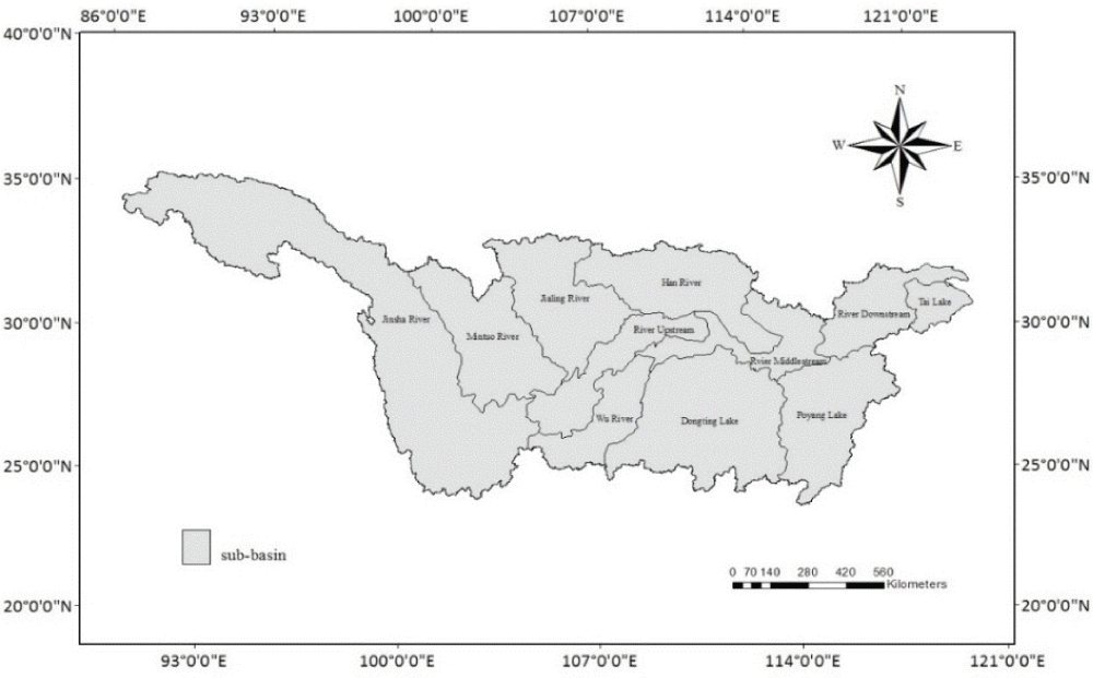
The research area is Yangtze River Basin, located in southern China about 1.8 million km2, lies between 24.50°N-35.75°N and 92.43°E-122.45°E [18] (Figure 1). Most parts of the basin have a subtropical monsoon climate [19-21] and the annual mean temperature in the basin is between 15 °C and 19 °C [21] with its average annual precipitation of 1067 mm [22].
All the data is extracted and classified by ERDAS 9.2 software from the Landsat 7 ETM+30 m resolution satellite imagery into different land uses, including forest, grassy land, agricultural land, built-up land, water, barren land, wetland, and desert land. Digital elevation model (DEM) data are also used and analyzed in topography (Table 1).
| Table 1: Database in estimating non-point source load | ||
| Data type | Data description | Data source |
| Digital elevation model (DEM) | At a spatial resolution of 30 × 30 m | The Earth System scientific data sharing platform http://www.geodata.cn/ |
| Land use map | 1:250000 Yangtze River Basin land use | The Earth System scientific data sharing platform http://www.geodata.cn/ |
| Precipitation | Precipitation data on the whole stations in the Yangtze River Basin | China Meteorological Science Data Sharing service |
The Improved Export Coefficient Model (IECM), applied in the research from the development of the Export Coefficient Model (ECM) of Johnes [23], combines with precipitation and terrain impact factors. The Improved Export Coefficient Model [24,25] allows accurate estimation of nutrient pollutants is described as:
Where:
L is the loss of nutrients (kg);
a is the precipitation impact factor;
ß is the terrain impact factor;
Ei is the export coefficient for nutrient source i (kg/km2yr);
Ai is the area of the catchment occupied by land use type i (km2);
Ii is the input of nutrients to source i (kg);
P is the input of nutrients from precipitation (kg).
The key parameters of the Export coefficient (Ei) are derived from literature sources and field data in past research (Table 2).
| Table 2: Export coefficient of NPS pollutant sources [24,25] | |||
| ID | Land use pattern | Estimating non-point source | |
| TN (kg/ha) | TP (kg/ha) | ||
| 1 | Forest land | 2.38 | 0.15 |
| 2 | Grassy land | 10 | 0.2 |
| 3 | Agricultural land | 29 | 0.9 |
| 4 | Urban construction land | 11 | 0.24 |
| 5 | Wetland | 0.2 | 0.01 |
| 6 | Water area | 0 | 0 |
| 7 | Desert land | 1 | 0.51 |
| 8 | Barren land | 2 | 0.08 |
Moreover, this research also applies self-organizing maps to expose the correlation of the factors affecting the NPS loads because SOM is a popular neural network model and can provide a topology-preserved map from the high dimensional space to map units and neighborhood relation by neighborhood relation. The simulation process is implemented as: First, identify the exact factors that affect non-point source pollution in the Yangtze River Basin. Some neurons are selected and the values of the components for each neuron are initialized too. Second, iterative training is performed where the neurons are adjusted in response to a set of training vectors; therefore, the neurons approximately minimize an integrated distance criterion. The last is visualization, where each neuron’s reference is displayed in lower dimensional space and plotted as a map.
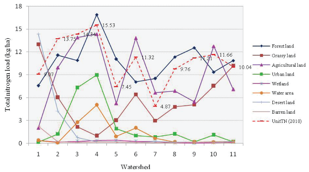
The whole Yangtze River basin can be divided into 11 sub-basins: (1) Jinsha River sub-basin; (2) Han River sub-basin; (3) River downstream sub-basin; (4) Tai Lake sub-basin; (5) Poyang lake sub-basin; (6) River middle stream sub-basin; (7) Dong ting lake sub-basin; (8) Wu River sub-basin; (9) River upstream sub-basin; (10) Jialing River sub-basin; (11) Min Tuo River sub-basin different land use types in 2010 and Figure 2 indicates that average contribution of total nitrogen occupies from 4.87 kg/ha to 15.53 kg/ha, in which the least contribution value locates at Dong ting lake sub-basin. Followed by the Poyang Lake sub-basin (7.45 kg/ha); Jinsha River sub-basin (9.07 kg/ha); Wu River sub-basin (9.76 kg/ha); Min Tuo River sub-basin (10.04 kg/ha); River upstream (11.21 kg/ha); River middle stream (11.32 kg/ha); Jialing River sub-basin (11.66 kg/ha); Han River sub-basin (13.75 kg/ha); River downstream (14.34 kg/ha); and the highest contribution value is at Tai Lake sub-basin with 15.53 kg/ha. Especially, at the Tai Lake sub-basin has both the highest average contribution and the highest TN load on forest, agricultural land, and urban construction land patterns, as well as the water area is the biggest. Moreover, with average contribution is low on the Jinsha River sub-basin, but the total nitrogen contribution on the grassy land and desert land pattern is the highest (Figure 2).
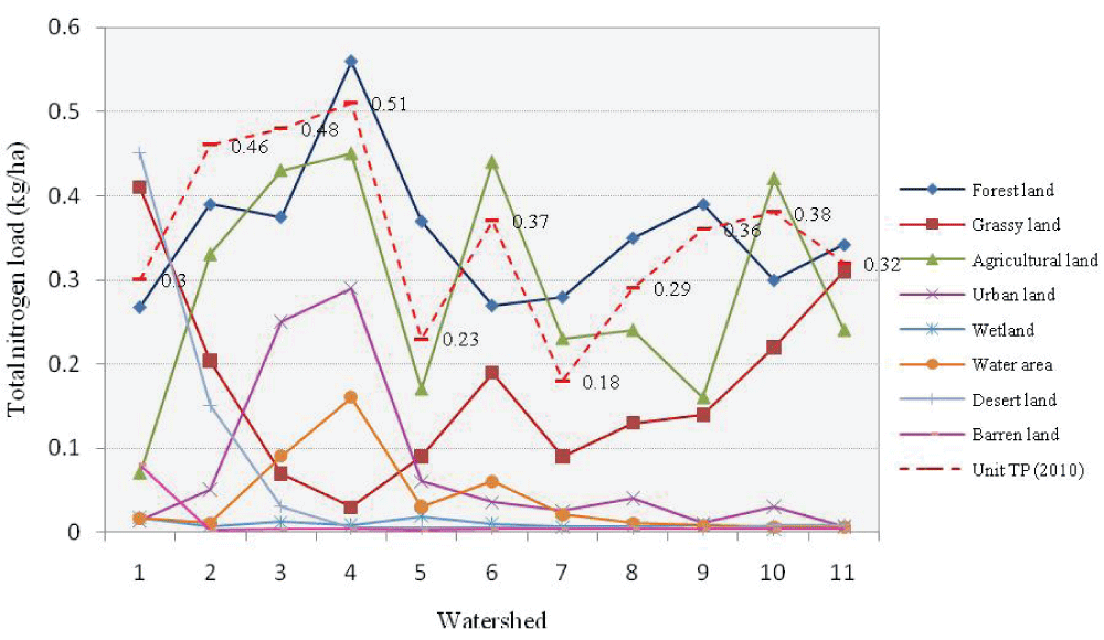
Besides, phosphorus is also one of the elements that causes NPS pollution, and the contribution of total phosphorus load in different land-use types is presented in Figure 3. It indicates that the average contribution line is from the lowest value to the highest value, from 0.18 kg/ha to 0.51 kg/ha respectively, in which the lowest average total phosphorus contribution is 0.18 kg/ha on the Dong ting Lake sub-basin. Following by the Poyang Lake sub-basin (0.23 kg/ha); Wu River sub-basin (0.29 kg/ha); Jinsha River sub-basin (0.3 kg/ha); Min Tuo River sub-basin (0.32 kg/ha); River upstream (0.36 kg/ha); River middle stream (0.37 kg/ha); Jialing River sub-basin (0.38 kg/ha); Han River sub-basin (0.46 kg/ha); River downstream (0.48 kg/ha); and Tai lake sub-basin with 0.51 kg/ha is the highest average total phosphorus contribution. Showing on the figure indicates very clearly that the Tai Lake sub-basin not only has the highest average total phosphorus contribution, but also has the highest total phosphorus contribution on the forest land, agricultural land, and urban construction land pattern. Besides, the highest total phosphorus contribution on the grassy land and desert land pattern belongs to the Jinsha River sub-basin with a medium total phosphorus average contribution (Figure 3).
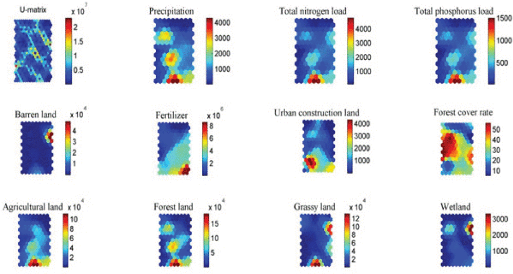
Via simulation of the self-organized map, Figure 4 includes many factors, that have affected non-point source pollution in the Yangtze River Basin, such as land-use factors such as barren land, urban construction land, agricultural land, forest land, grassy land, and wetland because land carries loading content of the non-point source and with different land-use presents different pollutant carrying. Moreover, precipitation, forest cover rate, and fertilizer are considered in correlation with different factors with non-point source load because precipitation directly carries pollutants from the atmosphere into the land and erosion of pollutants in the land due to rainfall intensity. Moreover, fertilizer increases the number of pollutants in the soil because of its residue in agricultural activities and the forest cover rate presents washing away pollutants from the air to land with high forest cover density. In factors correlation, neurons are displayed on the map with influencing factors regarded as components of each factor. They are represented by values from low value to high value, made clusters, and distributed at different portions on the map. Low value is respectively with blue color, and light blue for higher value, to yellow color, red color, and brown color for the highest value. Seeing on Figure 4 U-matrix represents the average distance of neurons. The neurons in the near distance and far distance are distributed intersperse on the whole map. The near-distance neurons make large clusters, but the far-distance neurons only make small clusters and locate between near-distance node clusters. Beside of U-matrix map is the precipitation factor map. On the map, the neurons create clusters clear. The lowest value neuron distributes in the large area on the upper right side and below the left side of the map. The Middle of the map is separated into three large clusters, made as a trip from the underside to the upper left side. They include high-value clusters and highest-value clusters. The high-value clusters are located in the middle of the map and the upper portion toward to upper left side of the map, but the highest-value cluster is created by two nodes and is located on under center side of the map. Surround those two nodes are neurons in lower value; they are displayed from yellow color to red color. Toward total nitrogen load and total phosphorus load factors, the distribution of neurons is the same as each other, but in different values. This meaning can show that those factors have a very close correlation with each other. The low-value neurons occupy most of the map. The medium neurons make two clusters and are located inside low-value node regions. Moreover, they are also distributed on the upper right side and under the right corner of the map. However, the highest value cluster is created by two nodes and located on under center side of the map. Surround those two nodes are neurons in lower value; they are displayed from yellow color to red color.
Moving down to fertilizer factor shows the highest value neurons in fertilizer factor distributed under the right corner in a cluster including four neurons. The medium value neurons create a large area and are located at the below portion toward to right side of the map. The low-value neurons are distributed on the upper portion toward to upper left corner of the map. Next is the forest cover rate factor, low-value neurons are separated into two large clusters, which are located at the upper right corner and below the left corner of the map. Middle of the map are medium-value and high-value neurons. The medium-value nodes are created in different clusters, and the highest-value nodes are located at the center-left side of the map. Moving toward agricultural land, forest land, and grassland factors, the high-value neurons are distributed at the same position on the under-center side of the map, in which the highest value nodes include two neurons. The low-value neurons distribute almost on the map toward to upper portion of the map. However, in the agricultural land and forestland factors, medium-value neurons are made clusters and located in the middle of low-value node areas. However, in the grassy land factor, the medium value neurons are created clusters and distributed on the right side of the map. Next are wetland and barren land factors, they have a similar distribution of neurons from low value to high value. The low-value neurons locate most of the map, and toward to left side of the map. The high-value neurons are made of clusters in different colors and are located at the upper right side of the map, with the highest value displayed by two hexagons and located at the upper right side of the map. The difference between these two factors is medium value nodes are in blue and are located inside the low-value neurons toward to upper left portion of the map in the wetland factor, while in the barren land factor does not appear this feature. In the urban construction land factors, high-value neurons are distributed on the below portion toward the left of the map, and the low-value neurons are the upper portion of the map. The surroundings of high-value neurons are medium-value nodes. Moreover, medium-value nodes are also located inside the low-value neuron area on the upper portion of the map.
Therefore, Figure 4 shows the distribution of neurons in different values on the map, and their correlations are presented as precipitation, total nitrogen load, and total phosphorus load factors correlate with the highest value, in which total nitrogen load and total phosphorus load factors have a close correlation with each other from the lowest value to the highest value. Wetland and barren land factors correlate with the lowest value and the highest value. Agricultural land, forestland, and grassy land factors correlate with one another in high value and the highest value. The forest cover rate factor, as well as the population factor, does not correlate with other factors.
From estimating non-point source load and identifying the correlation relationship of factors, this research has drawn some significant points:
Total nitrogen load is 4.87 - 15.53 kg/ha; total phosphorus load is 0.18 - 0.51 kg/ha; Dong Ting Lake sub-basin has the lowest contribution value of total nitrogen and phosphorus; the Tai Lake sub-basin has the highest contribution load of total nitrogen The and total phosphorus; Jinsha River sub-basin reveals the highest value of total nitrogen and phosphorus contribution on grassy land and desert land; Tai Lake sub-basin has the highest total nitrogen and total phosphorus load on forest, agricultural land, and urban construction land;
The correlation relationship of factors reveals a very close correlation with each other; precipitation, total nitrogen load, and total phosphorus load factors correlate with the highest value, in which total nitrogen load and total phosphorus load factors have close correlation with each other from the lowest value to highest value; wetland and barren land factors correlate with the lowest value and the highest value; agricultural land, forestland, and grassy land factors correlate with one another in the high value and the highest value. The forest cover rate factor, as well as the population factor, does not have any correlation with other factors.
Nguyen MI. Correlation between Different Factors of Non-point Source Pollution in Yangtze River Basin. IgMin Res. October 23, 2024; 2(10): 848-853. IgMin ID: igmin258; DOI:10.61927/igmin258; Available at: igmin.link/p258
Anyone you share the following link with will be able to read this content:
Address Correspondence:
Minh Thu Nguyen, Vietnam Institute of Meteorology, Hydrology and Climate Change, Ministry of Natural Resources and Environment, Vietnam, Email: [email protected]
How to cite this article:
Nguyen MI. Correlation between Different Factors of Non-point Source Pollution in Yangtze River Basin. IgMin Res. October 23, 2024; 2(10): 848-853. IgMin ID: igmin258; DOI:10.61927/igmin258; Available at: igmin.link/p258
Copyright: © 2024 Nguyen MT. This is an open access article distributed under the Creative Commons Attribution License, which permits unrestricted use, distribution, and reproduction in any medium, provided the original work is properly cited.
 Figure 1: Distribution of sub-basins in the Yangtze River Ba...
 Figure 2: Contribution of total nitrogen load....
 Figure 3: Contribution of total phosphorus load....
 Figure 4: Factor correlation in the Yangtze River Basin....